Date: September 11, 2026 Author: Yamada, Regional Revitalization Cooperation Team & Travel Journalist
Executive Overview
In an era dominated by high-speed digital engagement and urban congestion, the pursuit of genuine sensory restoration has become a primary driver for modern travelers. Nowhere is this transformation more palpable than along the rugged, breathtaking coastline of Fukui Prefecture’s Tsuruga and Wakasa regions. Bordering the Sea of Japan, this area has long been celebrated for its pristine waters, dramatic geological formations, and deeply rooted agricultural landscapes. However, recent localized reporting initiatives shed light on a profound truth often missed by mainstream tourism itineraries: true geographical healing cannot be captured through a camera lens alone. It requires a holistic immersion into the ambient air, shifting sea breezes, subtle scents of pine and salt, and the natural acoustic tapestry of the environment.
This comprehensive report examines the multifaceted tourism ecosystem of the Tsuruga and Wakasa areas as documented during late-summer field research in August 2026. By examining iconic sites—ranging from nationally designated terraced rice fields and historic Shinto-influenced coastlines to crystal-clear swimming beaches and ancient temples—this article explores how regional stakeholders are successfully blending sustainable tourism with profound ecological preservation. The findings offer a blueprint for travelers seeking slow-paced, soul-stirring retreats away from the relentless churn of metropolitan life.
Detailed Chronology: Field Observations from the Wakasa Bay Corridor
The late-summer expeditions conducted across the Tsuruga and Wakasa corridors between August 21 and August 24, 2026, revealed a dynamic landscape transitioning from the vibrant energy of peak beach season into the contemplative serenity of early autumn. The following chronological breakdown outlines the primary investigative stops along this coastal route.
1. The Sculpted Inlets of Takahama: Hibiki Rice Terraces and Wakamiya Beach
August 21, 2026: The journey commenced in Takahama Town, a municipality defined by the dramatic interplay between the Sea of Japan and towering coastal peaks, most notably the majestic Mount Aoba (Aobayama).
Hibiki Terraced Rice Fields: Perched along the steep slopes of the Uchiura Bay inlet, the Hibiki Rice Terraces represent an engineering and agricultural masterpiece. Comprising approximately 200 individual paddies carved into the hillside, this location was officially designated as one of Japan’s Top 100 Terraced Rice Fields in 1999. In late August, the stark visual contrast between the deep cobalt blue of the sea and the vibrant emerald green of mature rice stalks creates an arresting landscape that encapsulates rural Japanese heritage.
Wakamiya Beach & Taka Island: Transitioning from agriculture to maritime recreation, the reporting team visited Wakamiya Beach—the historic birthplace of Takahama’s swimming culture. Recently modernized with clean, streamlined coastal infrastructure, the beach benefits from its proximity to regional assets such as the UMIKARA seafood market and the Wakasa Takahama Sea Fishing Park. Framing the view are the evergreen forests of Taka Island and the looming silhouette of Mount Aoba, offering visitors a seamless blend of leisure and dramatic topography.
2. Panoramic Vistas and Coastal Engineering: Akagashizaki and Kusuyagatake
August 22, 2026: Operations shifted eastward into Oi Town and Obama City, focusing on elevated viewpoints designed to contextualize the vast geography of Wakasa Bay.
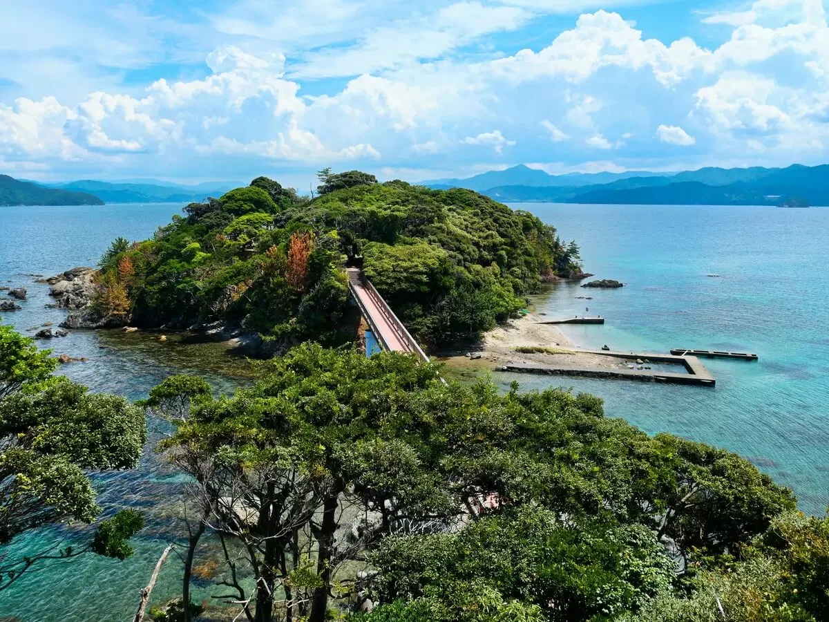
Akagashizaki Seaside Park: Situated adjacent to the Akagashizaki Auto Campground in Oi Town, this coastal park merges family-friendly infrastructure with untamed nature. A pedestrian bridge links the mainland to the isolated island housing the historic Akagashizaki Lighthouse. From the park’s 13-meter-high observation deck, visitors are treated to a sweeping panorama of Wakasa Bay, where the interplay of sea foam, rocky promontories, and maritime traffic creates a living canvas.
Kusuyagatake Observatory Scenic Drive: Spanning approximately 10 kilometers along the Obama coastline, this winding scenic route delivers motorists to the summit of Mount Kusuyagatake. Along the ascent, travelers encounter geological oddities such as Oogami-iwa (Wolf Rock), a massive rock formation that uncannily mimics the profile of a howling wolf depending on the viewing angle. The summit observatory provides a commanding 360-degree vista that, on exceptionally clear days, stretches as far as Cape Echizen Misaki to the north and the Tango Peninsula to the west.
3. Inland Ecosystems and Spiritual Heritage: Lake Mikata and Zuirinji Temple
August 23, 2026: The itinerary turned inward to examine the delicate ecological balance of the Mikata Five Lakes and the historical preservation efforts embedded in local religious sites.
Lake Mikata Nature Observation Building: Positioned directly on the shores of Lake Mikata—adjacent to the Mikata Goko Roadside Station—this lodge-style facility serves as both an educational hub and a sanctuary for ornithologists. The second-floor indoor viewing deck and open-air terrace offer uninterrupted vantages over the brackish lake waters, which play a critical migratory role for regional bird populations.
Zuirinji Temple (Mihama Town): Founded in 1430, this ancient Buddhist temple offers a masterclass in the intersection of spirituality and landscape architecture. Situated on a modest hill overlooking both the Sea of Japan and Lake Kugushi, Zuirinji is renowned for its cherry blossom displays in spring. However, its mid-summer profile—defined by lush, deep-green canopies—provides an equally powerful testament to the timeless aesthetic of Japanese temple grounds, serving historically as a favored location for cinematic storytelling.
4. Coastal Masterpieces: Suishohama Beach and Kehi no Matsubara
August 24, 2026: The final leg of the investigative journey evaluated the premier sandy ecosystems that anchor Fukui’s reputation as a premier aquatic destination.
Suishohama Beach (Mihama Town): Translating literally to "Crystal Water Beach," Suishohama justifies its moniker through exceptional water transparency and ultra-fine, quartz-rich white sand that physically sparkles under direct sunlight. Recognized in 2001 by the Ministry of the Environment as one of the "88 Best Beaches in Japan," the shoreline attracts a steady influx of regional and national tourists seeking pristine swimming conditions.
Kehi no Matsubara (Tsuruga City): The journey culminated at one of Japan’s Three Great Pine Groves (Nihon no San-Matsubara), alongside Miho no Matsubara in Shizuoka and Niji no Matsubara in Saga. Stretching for approximately one kilometer and encompassing an expanse of roughly 340,000 square meters, Kehi no Matsubara presents a striking, nationally designated scenic composition of snow-white sand dunes contrasted against deep emerald-green Japanese red and black pines. In the summer months, the perimeter transitions seamlessly into a bustling, highly regulated swimming beach, accommodating thousands of visitors from the Kansai and Chubu metropolitan corridors.
Supporting Context & Metrics
To fully comprehend the economic and cultural gravity of the Tsuruga and Wakasa regions, one must analyze the structural metrics governing regional tourism, ecological designations, and accessibility frameworks.
Table 1: Key Geographical and Infrastructural Metrics of the Tsuruga-Wakasa Corridor
Location Name
Municipal District
Primary Designation / Attraction
Key Infrastructural Access Point
Hibiki Terraced Rice Fields
Takahama Town
Top 100 Rice Terraces of Japan (1999)
45 min. drive from Maizuru-Wakasa IC
Wakamiya Beach
Takahama Town
Historic swimming beach / UMIKARA market
10 min. walk from JR Wakasa-Takahama Stn.
Akagashizaki Seaside Park
Oi Town
13m observation deck / Auto campground
20 min. drive from Maizuru-Nishi IC
Kusuyagatake Observatory
Obama City
10km scenic drive / Wolf Rock formation
25 min. drive from Obama IC
Lake Mikata Observation Deck
Wakasa Town
Wetland ornithology / Lake ecosystem
5 min. taxi from JR Mikata Stn.
Zuirinji Temple
Mihama Town
Founded 1430 / Historic cinematic backdrop
20 min. drive from Wakasa-Mihama IC
Suishohama Beach
Mihama Town
Top 88 Beaches in Japan (Min. of Environment)
30 min. drive from Wakasa-Mihama IC
Kehi no Matsubara
Tsuruga City
One of Japan’s Three Great Pine Groves
15 min. bus from JR Tsuruga Stn.
The Sensory Deficit in Modern Travel
Market research cited during the regional reporting underscores a growing consumer fatigue with hyper-curated, digitally mediated travel content. Algorithms prioritize high-saturation imagery, yet studies in environmental psychology confirm that human stress recovery relies heavily on multi-sensory inputs—specifically olfactory triggers (pine resin, salt air), auditory feedback (wave refraction, wind rustling through terraced paddies), and tactile engagement (fine quartz sand, coastal humidity). The Tsuruga-Wakasa region uniquely provides an environment where these sensory elements remain unpolluted by industrial noise or over-commercialization.
Official Perspectives and Regional Revitalization Insights
The revitalization of the Tsuruga and Wakasa corridors is not merely an accident of geography; it is the deliberate result of public-private cooperation aimed at reversing rural depopulation while preserving ecological integrity.
Yamada, a representative of the Fukui Prefecture Regional Revitalization Cooperation Team who relocated from an urban center to the region in 2026, offered critical insights into the philosophical shift required to appreciate the territory:
"Having lived in major metropolitan areas for the vast majority of my life, the sheer visceral impact of moving to the Tsuruga and Wakasa area was staggering. When you travel here for reporting, you quickly realize that the internet shows you only half the story. The digital screen strips away the air, the scent, the raw force of the wind, and the acoustic depth of the landscape. These are not secondary details—they are the core mechanisms of nature’s healing power. Our goal as local advocates is to remind travelers to put down their devices, breathe in the maritime air, and allow themselves to discover a personal, unhurried landscape of comfort."
Furthermore, municipal tourism associations across Tsuruga, Mihama, Wakasa, Oi, and Takahama have increasingly coordinated their marketing campaigns to emphasize sustainable slow tourism. Rather than promoting mass-market tourism models that strain local infrastructure, current regional directives focus on distributed itineraries. Visitors are encouraged to utilize integrated transit networks—such as the Gurutto Tsuruga Loop Bus and regional community lines—to move fluidly between coastal and inland zones, thereby minimizing carbon footprints while maximizing economic distribution to local family-owned enterprises, seafood markets, and traditional inns.
Future Outlook
As Japan’s tourism sector navigates the post-pandemic landscape, the challenge for rural coastal regions lies in balancing accessibility with ecological preservation. The Tsuruga and Wakasa corridors stand at a critical juncture. With major infrastructure projects—including expansions within the broader Hokuriku transit network—bringing these coastal sanctuaries within easier reach of Kansai and Chubu population centers, the risk of over-tourism is a persistent concern for local administrators.
However, the deliberate emphasis on multi-sensory, slow-paced travel models championed by regional revitalization teams offers a sustainable counter-strategy. By marketing the territory not as a collection of static photo-ops, but as an immersive sanctuary for mental and physical restoration, local stakeholders are cultivating a discerning class of traveler. These visitors are statistically more likely to respect local customs, engage in off-peak travel, and support conservation initiatives—such as the upkeep of Kehi no Matsubara’s fragile pine ecosystems and the preservation of hillside terraced farming at Hibiki.
Looking ahead, the continued success of the Tsuruga and Wakasa regions will depend on maintaining rigorous environmental protections while expanding digital transparency regarding seasonal accessibility (such as winter closures on mountain drives like Kusuyagatake). For the modern traveler seeking refuge from urban chaos, Wakasa Bay remains an enduring testament to the healing power of the natural world—a place where sea, mountain, lake, and sky converge in quiet, restorative harmony.
Note: All logistical details, operational hours, and access routes cited in this report are current as of August 26, 2026. Travelers are strongly advised to verify the latest operational statuses via the official tourism association portals of respective municipalities prior to departure.


![[Tsuruga/ Wakasa Area] A view overlooking the end of summer](https://resources.matcha-jp.com/resize/720x2000/2026/09/11-270650.webp)
![[Tsuruga/ Wakasa Area] A view overlooking the end of summer](https://resources.matcha-jp.com/resize/720x2000/2026/09/11-270651.webp)
![[Tsuruga/ Wakasa Area] A view overlooking the end of summer](https://resources.matcha-jp.com/resize/720x2000/2026/09/11-270653.webp)
![[Tsuruga/ Wakasa Area] A view overlooking the end of summer](https://resources.matcha-jp.com/resize/720x2000/2026/09/11-270654.webp)
![[Tsuruga/ Wakasa Area] A view overlooking the end of summer](https://resources.matcha-jp.com/resize/720x2000/2026/09/11-270655.webp)
![[Tsuruga/ Wakasa Area] A view overlooking the end of summer](https://resources.matcha-jp.com/resize/720x2000/2026/09/11-270656.webp)
![[Tsuruga/ Wakasa Area] A view overlooking the end of summer](https://resources.matcha-jp.com/resize/720x2000/2026/09/11-270657.webp)
![[Tsuruga/ Wakasa Area] A view overlooking the end of summer](https://resources.matcha-jp.com/resize/720x2000/2026/09/11-270658.webp)
![[Tsuruga/ Wakasa Area] A view overlooking the end of summer](https://resources.matcha-jp.com/resize/720x2000/2026/09/11-270659.webp)
![[Tsuruga/ Wakasa Area] A view overlooking the end of summer](https://resources.matcha-jp.com/resize/720x2000/2026/09/11-270660.webp)
![[Tsuruga/ Wakasa Area] A view overlooking the end of summer](https://resources.matcha-jp.com/resize/720x2000/2026/09/11-270661.webp)
![[Tsuruga/ Wakasa Area] A view overlooking the end of summer](https://resources.matcha-jp.com/resize/720x2000/2026/09/11-270662.webp)
![[Tsuruga/ Wakasa Area] A view overlooking the end of summer](https://resources.matcha-jp.com/resize/720x2000/2026/09/11-270663.webp)






Belum ada komentar. Jadilah yang pertama berkomentar!