For decades, international travelers exploring Japan have relied almost exclusively on the nation’s world-class rail networks. Trains offer unmatched punctuality, speed, and nationwide reach. However, relying purely on fixed rail schedules can inadvertently keep travelers on well-worn tourist tracks, rendering more rural, geographically nuanced regions difficult to access.
For those looking to venture beyond the urban sprawl of Tokyo and experience a side of Japan untouched by mass tourism, renting a vehicle and taking to the open road unlocks an entirely different dimension of travel. Just south of the capital lies Chiba Prefecture—a coastal frontier framed by Tokyo Bay and the Pacific Ocean.
While Northern Chiba is dominated by urban development and Narita International Airport, the southern stretch of the Boso Peninsula remains a haven of dramatic topography, deep-rooted maritime traditions, and ancient sacred spaces. This investigative travel feature explores a curated driving itinerary across Southern Chiba. It highlights critical civil engineering marvels, unique architectural adaptive reuse projects, millennium-old Buddhist sanctuaries carved directly into sheer rock faces, and a culinary landscape driven by the nutrient-rich waters of the Kuroshio Current.
Detailed Chronology of the Route
A comprehensive road journey through Southern Chiba demands a logical progression that capitalizes on both driving efficiency and scenic value. Below is the chronological breakdown of the ultimate Boso Peninsula driving itinerary.
Phase 1: Crossing Tokyo Bay via the Tokyo Bay Aqua-Line
The journey begins at the western approaches of the Tokyo Bay Aqua-Line Expressway, linking Kawasaki City in Kanagawa Prefecture directly with Kisarazu City in Chiba Prefecture. Drivers drop below sea level to traverse a 6-mile (9.6-kilometer) undersea tunnel before emerging onto an artificial island that houses the Umihotaru Parking Area.
From Umihotaru, motorists cross a 2.7-mile (4.4-kilometer) elevated bridge before making landfall in Chiba. Umihotaru—named after the bioluminescent ostracods native to the region—functions as a multi-story maritime hub equipped with observation decks, retail outlets, and regional dining.
Phase 2: Ascending Mount Nokogiri and Nihonji Temple
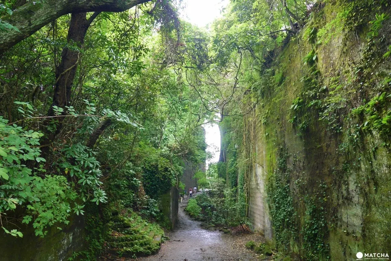
Leaving the coast, the route turns south toward the jagged ridges of Mount Nokogiri. Standing at a modest 1,080 feet (329.4 meters), the mountain’s dramatic profile is the result of centuries of quarrying for high-grade Boshu stone.
Visitors ascend the peak to explore Nihonji Temple, an ancient Buddhist complex established in the 8th century. The site features the monumental 102-foot (31.05-meter) Great Buddha of Yakushi Nyorai—the tallest carved stone Buddha in Japan—alongside hundreds of preserved Arhat statues and the vertiginous Jigoku Nozoki (Hell Viewpoint) overlook.
Phase 3: Adaptive Reuse at Roadside Station Hota Elementary School
Descending the mountain, the itinerary pauses at Roadside Station Hota Elementary School. Following the closure of the local institution, the municipal government and local stakeholders transformed the abandoned campus into a hybrid rest stop, restaurant complex, local farmers’ market, day-use hot spring, and overnight accommodation venue utilizing repurposed classrooms.
Phase 4: Sacred Architecture of Southern Boso: Daifukuji and Naguji Temples
Continuing deeper into the Boso Peninsula, the route encounters cliffside sanctuaries that showcase Japan’s historical syncretism of nature and architecture.
Daifukuji Temple (Gake Kannon): Built directly into a precipitous rock face, housing a sacred Kannon statue carved into a natural cave.
Naguji Temple (Nako Kannon): Perched halfway up a mountain slope as the final station of the historic Bando 33 Kannon Pilgrimage route, notable for its demon-carved gabled roof architecture.
Phase 5: Geological Wonders at Okinoshima Island and Tateyama Castle
At the southwestern tip of the peninsula lies Okinoshima Island, connected to the mainland via a sandbar formed during the catastrophic Great Kanto Earthquake of the Taisho period. The island offers marine biodiversity, coral reefs, and Jomon-era archaeological strata.
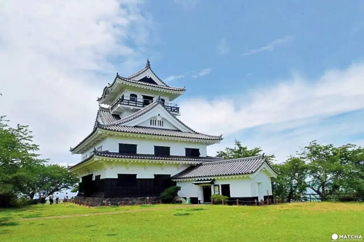
Adjacent to the coast is Tateyama Castle, a 16th-century fortress constructed by the Satomi clan. Its modern reconstruction serves as a museum dedicated to the legendary epic, The Tale of the Eight Dog Warriors (Satomi Hakkenden).
Phase 6: Coastal Culinary Finale and Return
The journey concludes along the coastal roadways of Tateyama and Southern Boso, where motorists sample the region’s legendary horse mackerel (aji), surf clams, and locally harvested seafood, before looping back north via the coastal highways.
Supporting Context & Infrastructure Metrics
To properly evaluate the logistics of a self-drive expedition in Chiba Prefecture, one must analyze the infrastructural, historical, and environmental data supporting the region.
The Tokyo Bay Aqua-Line Engineering Marvel
The Tokyo Bay Aqua-Line is one of Japan’s most ambitious civil engineering projects. Completed in 1997 after decades of planning, it cut travel times between Kanagawa and Chiba from upwards of 90 minutes around the bay’s northern perimeter to a direct 15-minute aquatic crossing.
Umihotaru Mid-Bay Island: Acts as an artificial ventilation shaft and maritime rest stop. The distinctive sail-shaped structure visible from the island is the Kawasaki Artificial Island ventilation tower.
Toll Management: Umihotaru features dedicated U-turn lanes. This architectural layout allows motorists from either mainland approach to visit the rest stop, dine, and turn back without paying the full cross-bay transit tariff, boosting tourism accessibility.
Environmental Shifts and Marine Conservation
The namesake of the Umihotaru rest area—the sea firefly (Vargula hilgendorfii or umi-hotaru)—is a tiny benthic crustacean measuring roughly 3 millimeters in length. When agitated, these creatures secrete a luciferin-luciferase protein reaction that emits a brilliant, luminescent blue glow.
Ecological Decline: Once found in massive swarms along Chiba’s Pacific and bay coastlines, their populations have suffered dramatic declines due to coastal reclamation, industrial runoff, and changes in water turbidity.
Conservation Initiatives: Local municipal groups, marine biologists, and educational institutions run conservation breeding programs and water quality monitoring initiatives to protect remaining habitats.
Quarrying Heritage of Mount Nokogiri
Mount Nokogiri’s sharp, vertical topography is entirely anthropogenic. For generations, the mountain yielded Boshu stone, a soft, durable volcanic tuff utilized extensively during the Edo, Meiji, and Taisho periods.
Historical Applications: Boshu stone was shipped across Tokyo Bay to reinforce military fortifications, construct maritime ports in Yokohama and Yokosuka, build foundations for the Yasukuni Shrine, and pave early expansion projects at Waseda University.
Industrial Cessation: Commercial quarrying ceased entirely in 1982 following growing environmental and structural stability concerns. The site was subsequently zoned for preservation and tourism development, turning industrial scars into dramatic landscapes often likened to anime settings such as Studio Ghibli’s Castle in the Sky.
Official Statements & Stakeholder Insights
Regional tourism authorities and municipal planners emphasize the strategic importance of shifting traveler demographics away from rail-locked metropolitan itineraries toward automotive regional tourism.
"For too long, Chiba Prefecture has been viewed merely as a transit corridor connecting Narita Airport to Tokyo, or as a weekend day-trip destination for theme parks," states a senior regional development officer with the Boso Peninsula Tourism Promotion Bureau. "The true cultural depth of our prefecture—our 8th-century cliffside temples, our maritime culinary traditions, and our post-industrial geological parks—cannot be efficiently experienced from a train window. Promoting self-drive tourism is essential for distributing economic benefits to rural communities that rail networks bypass."
Local preservationists managing the historical ruins of Mount Nokogiri highlight the ongoing balance between heritage conservation and public access.
"The structures carved into Nihonji Temple and the remnants of the stone quarries represent a delicate synthesis of human labor and natural topography," notes a site curator at the temple complex. "Every visitor fee collected directly funds the seismic stabilization of our cliff faces and the restoration of stone statues damaged by weathering and historical fires. Motorists bring an independent demographic of travelers who stay longer, explore deeper, and contribute directly to the longevity of these cultural assets."
Municipal leaders overseeing the Roadside Station Hota Elementary School project view adaptive reuse as a blueprint for rural revitalization across aging Japanese demographics.
"When rural schools close due to declining birth rates, it deals a severe psychological blow to the community," explains a local municipal planning director. "By repurposing classrooms into hot springs, restaurants, and guest rooms, we haven’t just created a successful commercial enterprise—we have preserved the institutional memory of the town while inviting a new generation of motorists to experience rural hospitality firsthand."
Future Outlook
As Japan’s tourism sector continues to shatter inbound visitation records, urban congestion in destinations like Kyoto, Tokyo, and Osaka has intensified calls for sustainable regional dispersal. Chiba Prefecture is uniquely positioned to absorb this excess demand, provided infrastructural adaptations continue to support independent motorists.
1. Expansion of EV Charging Infrastructure
With the global automotive sector transitioning toward electrification, regional authorities along the Boso Peninsula are actively expanding electric vehicle (EV) charging stations at key roadside nodes, including Umihotaru and Roadside Station Hota Elementary School. Ensuring seamless range confidence for international drivers renting EVs is a primary municipal target for the coming decade.
2. Multilingual Navigation and Digital Integration
While physical road signage across Chiba features English translations, local prefectural agencies are investing in advanced GPS and digital mapping integrations. These platforms highlight real-time parking availability at narrow coastal trailheads (such as Okinoshima Island and Mount Nokogiri) to prevent traffic bottlenecks during peak weekend periods.
3. Culinary Sustainability and Agritourism Integration
The culinary identity of Southern Chiba—anchored by the Kuroshio Current’s rich marine harvest—faces future challenges from marine warming trends and shifting fish migration patterns. Future tourism models are pivoting toward sustainable gastronomy, encouraging self-drive visitors to patronize direct-to-consumer fish markets, local agricultural cooperatives, and family-run seaside eateries.
By breaking away from the rigidity of train timetables and embracing the freedom of the open road, travelers discovering Southern Chiba unlock a deeply authentic, historically rich, and visually stunning frontier of Japan that remains waiting to be explored.












Belum ada komentar. Jadilah yang pertama berkomentar!